


Entre-deux-Kiki-16102022

kayamb
User
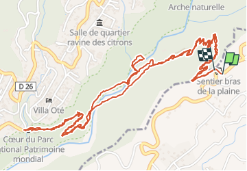

Length
6.8 km

Max alt
538 m

Uphill gradient
534 m
Km-Effort
13.9 km

Min alt
229 m

Downhill gradient
543 m
Boucle
Yes
Creation date :
2022-10-16 01:55:24.0
Updated on :
2022-10-16 03:21:52.907
1h15
Difficulty : Medium

FREE GPS app for hiking
 SityTrail
IGN / Geographical institutes
SityTrail Plus
The world is yours!
About
Trail Trail of 6.8 km to be discovered at Réunion, Unknown, Le Tampon. This trail is proposed by kayamb.
Positioning
Country:
France
Region :
Réunion
Department/Province :
Unknown
Municipality :
Le Tampon
Location:
Unknown
Start:(Dec)
Start:(UTM)
343161 ; 7649577 (40K) S.
Comments